Food nearby SPAR Selcourt
South Africa
Food nearby SPAR Selcourt
SPAR Selcourt
197, Nigel Road, 1559, Springs, East Rand, ZA South Africa
contacts phone
:
+27 11 818 5811
website:
www.spar.co.za
Latitude:
-26.3047218
, Longitude:
28.4472518
larger map & directions
read more
nearest Food
151 m
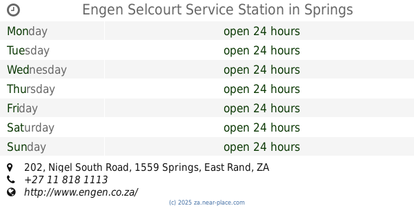
Engen Selcourt Service Station
202 Nigel South Road, Selcourt, Springs
Gas station
Convenience store
Car repair
Restaurant
Food
Point of interest
Store
Establishment
read more
155 m
Debonairs Pizza
Shop No 1 Selcourt Shopping Centre Cnr Nigel Road &, Charterland Avenue, Selcourt, Springs
Meal takeaway
Restaurant
Food
Point of interest
Establishment
read more
348 m
KFC Selcourt
No.181, Cnr Nigel &, Caribou Road, Roads, Springs
Meal takeaway
Restaurant
Food
Point of interest
Establishment
read more
4.853 km
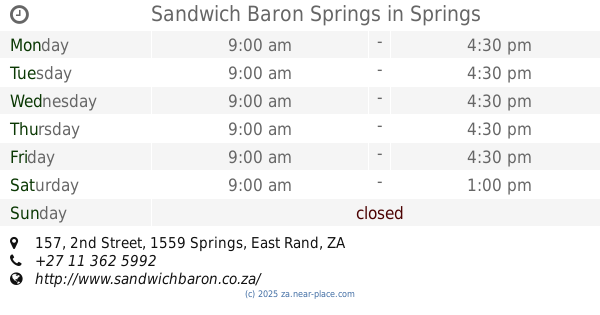
Sandwich Baron Springs
157 2nd Street, Springs New, Springs
Meal delivery
Meal takeaway
Restaurant
Food
Point of interest
Establishment
read more
5.46 km
KING PIE
33, The Avenue Shopping Centre, 1994 Cnr Post Office Aven & 4th Street, Springs New, Springs
Bakery
Meal takeaway
Restaurant
Food
Point of interest
Store
Establishment
read more
5.704 km
SPAR Strubenvale
3 Largo Road, Strubenvale, Springs
Grocery or supermarket
Supermarket
Food
Point of interest
Store
Establishment
read more
5.753 km
Pick n Pay Strubenvale
Corner of Hansim Road & Ermelo Roads, Strubenvale, Springs
Supermarket
Grocery or supermarket
Food
Point of interest
Store
Establishment
read more
10.058 km
Alles Is Aan Productions
Johannesburg, 451 Petunia Street, Geluksdal, Brakpan
Meal delivery
Food
Point of interest
Establishment
read more
11.324 km
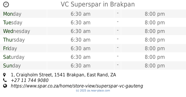
VC Superspar
1 Craigholm Street, Dalview, Brakpan
Supermarket
Grocery or supermarket
Food
Point of interest
Store
Establishment
read more
11.965 km
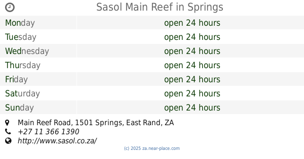
Sasol Main Reef
Cnr Paul Kruger Hwy &, Main Reef Road, Springs
Gas station
Convenience store
Bakery
Cafe
Car repair
Food
Point of interest
Store
Establishment
read more
12.514 km
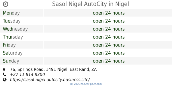
Sasol Nigel AutoCity
76 Springs Road, Glenverloch, Nigel
Convenience store
Food
Point of interest
Store
Establishment
read more
12.58 km
Picanha Nigel
50 Springs Road, Nigel
Lodging
Bar
Restaurant
Food
Point of interest
Establishment
read more
12.58 km
Nigel Goldfields Lodge & Functions
R51, 50 Springs Road, Nigel
Lodging
Bar
Restaurant
Food
Point of interest
Establishment
read more
14.013 km
Rizi's cakes for fun
90 Phlox Road, Welgedacht, Springs
Bakery
Food
Point of interest
Store
Establishment
read more
14.036 km
Carnival City Casino
& Century Rd, Elsburg Road, Brakpan, Boksburg
Casino
Lodging
Restaurant
Food
Point of interest
Establishment
read more
14.134 km
Checkers LiquorShop Mall Of Carnival
Cnr Airport and, Heidelberg Road, Dalpark, Brakpan
Liquor store
Bakery
Finance
Travel agency
Food
Point of interest
Store
Establishment
read more
14.371 km
SPAR Ferryvale
25 Beverley Road, Ferryvale, Nigel
Grocery or supermarket
Supermarket
Food
Point of interest
Store
Establishment
read more
14.389 km
Makro Store Carnival
16 Beechwood St Brakpan, Boksburg
Department store
Supermarket
Grocery or supermarket
Home goods store
Food
Point of interest
Clothing store
Store
Establishment
read more
15.204 km
Sunbake Benoni
3 Apex Road, Apex, Benoni
Bakery
Food
Point of interest
Store
Establishment
read more
18.619 km
Franchise Guest House
134 Howard Avenue, Benoni
Lodging
Bar
Restaurant
Food
Point of interest
Establishment
read more
18.979 km
Café Bellini
204 Elston Avenue, Benoni
Cafe
Restaurant
Food
Point of interest
Establishment
read more
19.008 km
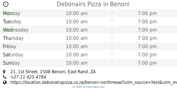
Debonairs Pizza
21 1st Street, Northmead, Benoni
Meal takeaway
Restaurant
Food
Point of interest
Establishment
read more
19.51 km
Coffeespoonz & Afternoons
101 Fifth Avenue, Northmead, Benoni
Cafe
Food
Point of interest
Store
Establishment
read more
19.711 km
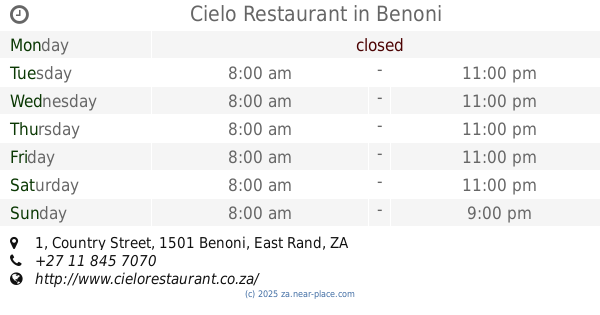
Cielo Restaurant
1 Country Street, Lakefield, Benoni
Cafe
Bar
Restaurant
Food
Point of interest
Store
Establishment
read more
19.953 km
Grapes Pub & Restaurant
Benoni Lake Club on Lakefield Ave Cnr Edward &, Divot Street, Benoni
Bar
Restaurant
Food
Point of interest
Establishment
read more
📑
all categories
Accounting
Administrative area level 1
Administrative area level 2
Airport
Amusement park
Aquarium
Art gallery
Atm
Bakery
Bank
Bar
Beauty salon
Bicycle store
Book store
Bowling alley
Bus station
Cafe
Campground
Car dealer
Car rental
Car repair
Car wash
Casino
Cemetery
Church
City hall
Clothing store
Colloquial area
Convenience store
Courthouse
Dentist
Department store
Doctor
Electrician
Electronics store
Embassy
Establishment
Finance
Fire station
Florist
Food
Funeral home
Furniture store
Gas station
General contractor
Grocery or supermarket
Gym
Hair care
Hardware store
Health
Hindu Temple
Home goods store
Hospital
Insurance agency
Jewelry store
Laundry
Lawyer
Library
Light rail station
Liquor store
Local government office
Locality
Locksmith
Lodging
Meal delivery
Meal takeaway
Mosque
Movie rental
Movie theater
Moving company
Museum
Natural feature
Neighborhood
Night club
Painter
Park
Parking
Pet store
Pharmacy
Physiotherapist
Place of worship
Plumber
Point of interest
Police
Political
Post office
Premise
Real estate agency
Restaurant
Roofing contractor
Route
Rv park, camping
School
Shoe store
Shopping mall
Spa
Stadium
Storage
Store
Subpremise
Subway station
Supermarket
Synagogue
Taxi stand
Train station
Transit station
Travel agency
University
Veterinary care
Zoo
administrative area level 3
sublocality level 1
sublocality level 2
↑