Store nearby Edgars - Boksburg
South Africa
Store nearby Edgars - Boksburg
Edgars - Boksburg
95, Commissioner Street, 1459, Boksburg, East Rand, ZA South Africa
contacts phone
:
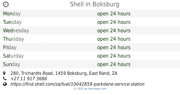
+27 11 917 5310
website:
www.edgars.co.za
Latitude:
-26.2196142
, Longitude:
28.2377376
larger map & directions
read more
nearest Store
1.127 km
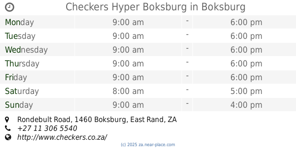
Checkers Hyper Boksburg
Cnr Leeupoort Street &, Rondebult Road, Parklands, Boksburg
Bakery
Supermarket
Grocery or supermarket
Finance
Electronics store
Travel agency
Home goods store
Food
Point of interest
Store
Establishment
read more
1.176 km
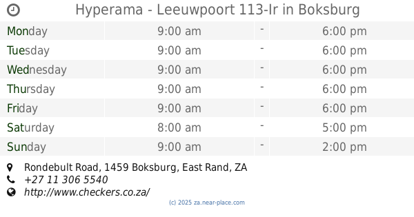
Hyperama - Leeuwpoort 113-Ir
Rondebult Road, Parkdene, Boksburg
Supermarket
Grocery or supermarket
Food
Point of interest
Store
Establishment
read more
1.325 km
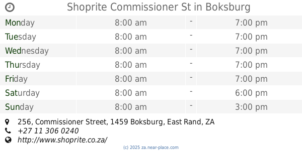
Shoprite Commissioner St
256 Commissioner Street, Boksburg North, Boksburg
Supermarket
Bakery
Grocery or supermarket
Finance
Travel agency
Liquor store
Food
Point of interest
Store
Establishment
read more
1.337 km
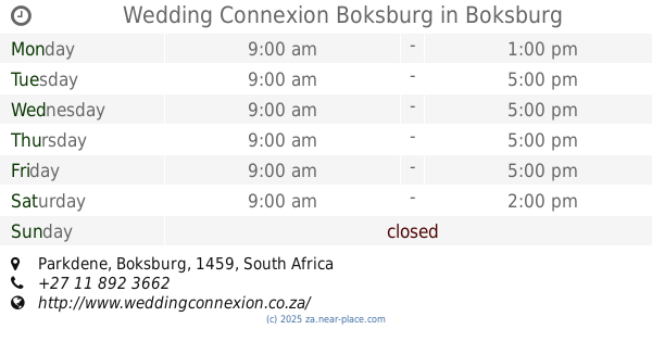
Wedding Connexion Boksburg
Parkdene, Boksburg
Point of interest
Clothing store
Store
Establishment
read more
1.53 km
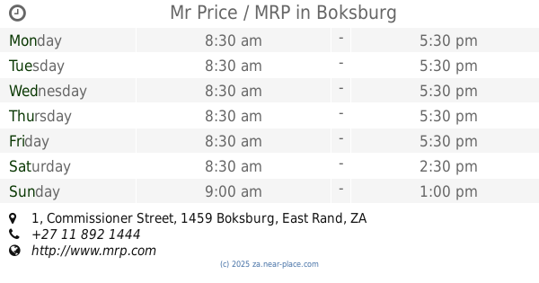
Mr Price / MRP
Shop, 1 Commissioner Street, East Rand, Boksburg
Clothing store
Shoe store
Point of interest
Store
Establishment
read more
1.566 km
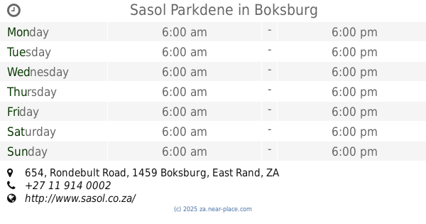
Sasol Parkdene
654 Rondebult Road, Parkdene, Boksburg
Gas station
Convenience store
Bakery
Cafe
Car repair
Food
Point of interest
Store
Establishment
read more
1.657 km
fashion world
299 Commissioner Street, Boksburg, Johannesburg
Clothing store
Shoe store
Point of interest
Store
Establishment
read more
1.703 km
Big G Gold
316 Rondebult Avenue, Parkrand, Johannesburg
Jewelry store
Finance
Point of interest
Store
Establishment
read more
1.894 km
CALEDONIAN MOTORS
Cnr Rietfontein Rd, 1 5th Street, Boksburg North, Johannesburg
Car dealer
Point of interest
Store
Establishment
read more
1.963 km
Muffin Mate SA (Pty Ltd)
295 Commissioner Street, Boksburg
Bakery
Food
Point of interest
Store
Establishment
read more
1.989 km
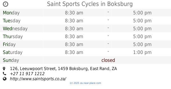
Saint Sports Cycles
126 Leeuwpoort Street, Boksburg
Bicycle store
Point of interest
Store
Establishment
read more
2.167 km
A & A Cell, Cycle And Electronics
Shop No. 46, Cason Road, Boksburg North, Johannesburg
Bicycle store
Electronics store
Point of interest
Store
Establishment
read more
2.186 km
Zoe Christian Bookshop & Coffeeshop
37 Rietfontein Road, Comet, Boksburg
Book store
Cafe
Food
Point of interest
Store
Establishment
read more
2.315 km
Frans E Marx Orthotics
162 Konig Road, Boksburg South, Boksburg
Shoe store
Health
Point of interest
Store
Establishment
read more
2.322 km
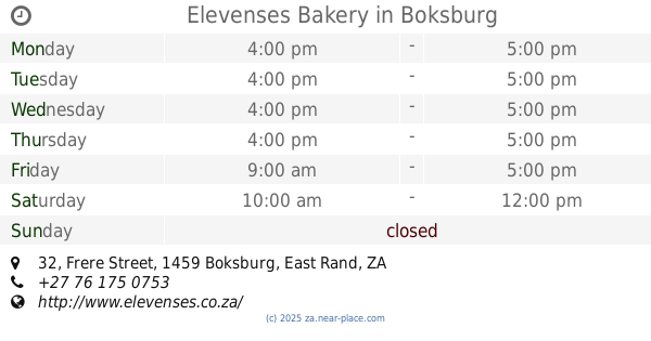
Elevenses Bakery
32 Frere Street, Boksburg
Bakery
Food
Point of interest
Store
Establishment
read more
2.36 km
G H B Electrical
14 10th Street, Boksburg North, Boksburg
Electrician
Point of interest
Store
Establishment
read more
2.593 km
tops at SPAR
Kruger Street, Boksburg, Johannesburg
Liquor store
Point of interest
Store
Establishment
read more
2.638 km
Masonic Liquor Store
Leeuwpoort Street, Boksburg, Johannesburg
Liquor store
Point of interest
Store
Establishment
read more
2.688 km
Sasol Rietfontein
71 Rietfontein Road, Boksburg West, Boksburg
Gas station
Car wash
Convenience store
Bakery
Car repair
Food
Point of interest
Store
Establishment
read more
2.69 km
OUDE MEESTER
1st Street, Boksburg North, Johannesburg
Bar
Point of interest
Store
Establishment
read more
2.728 km
Shell
280 Trichardts Road, Boksburg
Gas station
Atm
Convenience store
Finance
Food
Point of interest
Store
Establishment
read more
2.907 km
BizzBuzz
Rietfontein Road, Boksburg West, Boksburg
Book store
Point of interest
Store
Establishment
read more
2.912 km
Shoprite Boksburg North
98 8th Street, Boksburg North, Boksburg
Supermarket
Bakery
Grocery or supermarket
Liquor store
Food
Point of interest
Store
Establishment
read more
2.969 km
Sasol Ravenswood West
696 Rondebult Road, Ravenswood, Boksburg
Gas station
Convenience store
Bakery
Cafe
Car repair
Food
Point of interest
Store
Establishment
read more
3.049 km
FreshStop at Caltex Farrar Park
Rondebult Road, Boksburg
Convenience store
Gas station
Cafe
Food
Point of interest
Store
Establishment
read more
📑
all categories
Accounting
Administrative area level 1
Administrative area level 2
Airport
Amusement park
Aquarium
Art gallery
Atm
Bakery
Bank
Bar
Beauty salon
Bicycle store
Book store
Bowling alley
Bus station
Cafe
Campground
Car dealer
Car rental
Car repair
Car wash
Casino
Cemetery
Church
City hall
Clothing store
Colloquial area
Convenience store
Courthouse
Dentist
Department store
Doctor
Electrician
Electronics store
Embassy
Establishment
Finance
Fire station
Florist
Food
Funeral home
Furniture store
Gas station
General contractor
Grocery or supermarket
Gym
Hair care
Hardware store
Health
Hindu Temple
Home goods store
Hospital
Insurance agency
Jewelry store
Laundry
Lawyer
Library
Light rail station
Liquor store
Local government office
Locality
Locksmith
Lodging
Meal delivery
Meal takeaway
Mosque
Movie rental
Movie theater
Moving company
Museum
Natural feature
Neighborhood
Night club
Painter
Park
Parking
Pet store
Pharmacy
Physiotherapist
Place of worship
Plumber
Point of interest
Police
Political
Post office
Premise
Real estate agency
Restaurant
Roofing contractor
Route
Rv park, camping
School
Shoe store
Shopping mall
Spa
Stadium
Storage
Store
Subpremise
Subway station
Supermarket
Synagogue
Taxi stand
Train station
Transit station
Travel agency
University
Veterinary care
Zoo
administrative area level 3
sublocality level 1
sublocality level 2
↑