Point of interest nearby House of Nations
South Africa
Point of interest nearby House of Nations
House of Nations
John Collins Street, 1459, Reigerpark, Boksburg, East Rand, ZA South Africa
contacts phone
:
+27 11 529 5064
website:
houseofnations.co.za
Latitude:
-26.2305593
, Longitude:
28.2314518
larger map & directions
read more
nearest Point of interest
196 m
FNB - ATM
Reiger Park, Boksburg
Atm
Finance
Point of interest
Establishment
read more
522 m
Alpha Funeral directors
18 Vlamboom Street, Reiger Park, Boksburg
Funeral home
Point of interest
Establishment
read more
532 m
Masjidun-Noor (Reiger Park)
Goedehoop Avenue, Reiger Park, Boksburg
Mosque
Place of worship
Point of interest
Establishment
read more
679 m
WJ Clemments Stadium
6 Goedehoop Avenue, Reiger Park, Boksburg
Stadium
Point of interest
Establishment
read more
1.408 km
St. Michael and All Angels' Anglican Church
150 Commissioner Street, Boksburg
Church
Place of worship
Point of interest
Establishment
read more
1.473 km
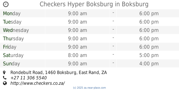
Checkers Hyper Boksburg
Cnr Leeupoort Street &, Rondebult Road, Parklands, Boksburg
Bakery
Supermarket
Grocery or supermarket
Finance
Electronics store
Travel agency
Home goods store
Food
Point of interest
Store
Establishment
read more
1.489 km
ABSA ATM
Checkers Hyper Centre, Rondebult Road, Boksburg, Johannesburg
Atm
Finance
Point of interest
Establishment
read more
1.535 km
Kings Tavern
16 Church Street, Boksburg
Bar
Restaurant
Food
Point of interest
Establishment
read more
1.634 km
Parkdene Medical Centre
26°13'40. 28°15'16 318 Trichardt street, Parkdene, Boksburg
Hospital
Health
Point of interest
Establishment
read more
1.65 km
FNB - ATM
Sierboom Street, Reiger Park, Boksburg
Atm
Finance
Point of interest
Establishment
read more
1.665 km
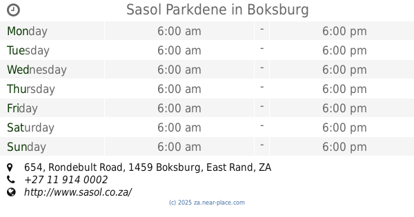
Sasol Parkdene
654 Rondebult Road, Parkdene, Boksburg
Gas station
Convenience store
Bakery
Cafe
Car repair
Food
Point of interest
Store
Establishment
read more
1.671 km
FNB - ATM
654 Rondebult Road, Parkdene, Boksburg
Atm
Finance
Point of interest
Establishment
read more
1.733 km
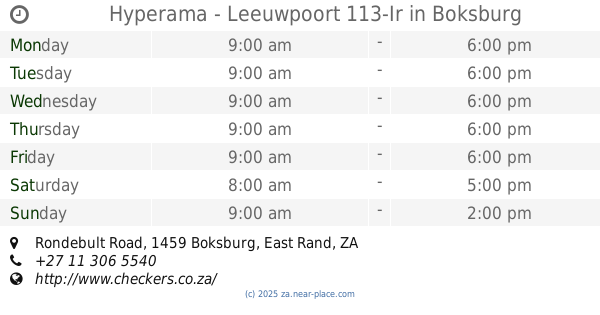
Hyperama - Leeuwpoort 113-Ir
Rondebult Road, Parkdene, Boksburg
Supermarket
Grocery or supermarket
Food
Point of interest
Store
Establishment
read more
1.765 km
Big G Gold
316 Rondebult Avenue, Parkrand, Johannesburg
Jewelry store
Finance
Point of interest
Store
Establishment
read more
1.777 km
Leeuwpoort Street Musallah
Commissioner Street, Boksburg
Mosque
Place of worship
Point of interest
Establishment
read more
1.813 km
Boksburg Fire Station
Adderley Street, Boksburg, Johannesburg
Fire station
Point of interest
Establishment
read more
1.899 km
Fire Station - Boksburg Central (DHQ)
Leeuwpoort Street, Boksburg South, Boksburg
Fire station
Point of interest
Establishment
read more
1.961 km
Bidvest Car Rental Boksburg
243 Rondebult Road, Farrar Park, Boksburg
Car rental
Point of interest
Establishment
read more
2.007 km
Casa Do Campo Portuguese Restaurant & Pub
239 Rondebult Road, Farrar Park, Boksburg
Bar
Restaurant
Food
Point of interest
Establishment
read more
2.048 km
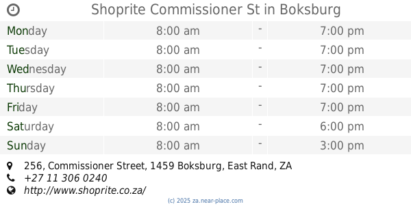
Shoprite Commissioner St
256 Commissioner Street, Boksburg North, Boksburg
Supermarket
Bakery
Grocery or supermarket
Finance
Travel agency
Liquor store
Food
Point of interest
Store
Establishment
read more
2.191 km
Caltex Car Wash
Rondebult Road, Boksburg, Johannesburg
Car wash
Point of interest
Establishment
read more
2.2 km
Property Active Boksburg
Rondebult Road, Farrar Park, Boksburg
Real estate agency
Point of interest
Establishment
read more
2.228 km
FNB - ATM
Bedford Road, Farrar Park, Boksburg
Atm
Finance
Point of interest
Establishment
read more
2.308 km
Slender Inch By Inch Passive Exercise Gym
219 Rondebult Road, Farrar Park, Johannesburg
Gym
Health
Point of interest
Establishment
read more
2.312 km
Sharee Jones Physiotherapy
219 Rondebult Road, Farrar Park, Boksburg
Physiotherapist
Health
Point of interest
Establishment
read more
📑
all categories
Accounting
Administrative area level 1
Administrative area level 2
Airport
Amusement park
Aquarium
Art gallery
Atm
Bakery
Bank
Bar
Beauty salon
Bicycle store
Book store
Bowling alley
Bus station
Cafe
Campground
Car dealer
Car rental
Car repair
Car wash
Casino
Cemetery
Church
City hall
Clothing store
Colloquial area
Convenience store
Courthouse
Dentist
Department store
Doctor
Electrician
Electronics store
Embassy
Establishment
Finance
Fire station
Florist
Food
Funeral home
Furniture store
Gas station
General contractor
Grocery or supermarket
Gym
Hair care
Hardware store
Health
Hindu Temple
Home goods store
Hospital
Insurance agency
Jewelry store
Laundry
Lawyer
Library
Light rail station
Liquor store
Local government office
Locality
Locksmith
Lodging
Meal delivery
Meal takeaway
Mosque
Movie rental
Movie theater
Moving company
Museum
Natural feature
Neighborhood
Night club
Painter
Park
Parking
Pet store
Pharmacy
Physiotherapist
Place of worship
Plumber
Point of interest
Police
Political
Post office
Premise
Real estate agency
Restaurant
Roofing contractor
Route
Rv park, camping
School
Shoe store
Shopping mall
Spa
Stadium
Storage
Store
Subpremise
Subway station
Supermarket
Synagogue
Taxi stand
Train station
Transit station
Travel agency
University
Veterinary care
Zoo
administrative area level 3
sublocality level 1
sublocality level 2
↑