Place of worship nearby House of Nations
South Africa
Place of worship nearby House of Nations
House of Nations
John Collins Street, 1459, Reigerpark, Boksburg, East Rand, ZA South Africa
contacts phone
:
+27 11 529 5064
website:
houseofnations.co.za
Latitude:
-26.2305593
, Longitude:
28.2314518
larger map & directions
read more
nearest Place of worship
532 m
Masjidun-Noor (Reiger Park)
Goedehoop Avenue, Reiger Park, Boksburg
Mosque
Place of worship
Point of interest
Establishment
read more
1.408 km
St. Michael and All Angels' Anglican Church
150 Commissioner Street, Boksburg
Church
Place of worship
Point of interest
Establishment
read more
1.777 km
Leeuwpoort Street Musallah
Commissioner Street, Boksburg
Mosque
Place of worship
Point of interest
Establishment
read more
2.474 km
The Boksburg Baptist Church
Market Street, Eloff Street, Boksburg
Church
Place of worship
Point of interest
Establishment
read more
2.753 km
Breakthru Church Boksburg
61 Heidelberg Road, Leeuwpoort 113-Ir, Boksburg
Church
Place of worship
Point of interest
Establishment
read more
3.669 km
Masjid Abu Bakr Siddique
1 Joubert Street, Elsburg, Germiston
Mosque
Place of worship
Point of interest
Establishment
read more
4.526 km
WnL - Woord en Lewe / Word and Life Church
cor Trichardts Rd &, Kingfisher Avenue, Sunward Park, Boksburg
Church
Place of worship
Point of interest
Establishment
read more
6.353 km
Hazeldene Musallah
17 Wiletta Street, Hazel Park, Germiston
Mosque
Place of worship
Point of interest
Establishment
read more
6.709 km
Germiston Mosque
High Street, Georgetown, Germiston
Mosque
Place of worship
Point of interest
Establishment
read more
7.007 km
Lakefield Mosque Musjid-ul-Ansaar, Benoni
Atlas Road, Benoni
Mosque
Place of worship
Point of interest
Establishment
read more
7.432 km
Masjid un Noor
Soma Street, Actonville, Benoni
Mosque
Place of worship
Point of interest
Establishment
read more
8.986 km
El-Shammah Ministries International
69a Churchill Avenue, Primrose, Germiston
Church
Place of worship
Point of interest
Establishment
read more
9.159 km
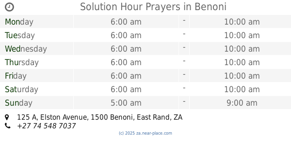
Solution Hour Prayers
125 A Elston Avenue, Benoni
Church
Place of worship
Point of interest
Establishment
read more
9.329 km
Al- Zabih Masjid
52 Newlands Avenue, Benoni
Mosque
Place of worship
Point of interest
Establishment
read more
9.336 km
Benoni Central Methodist Church
26 Bunyan Street, Benoni, Johannesburg
Church
Place of worship
Point of interest
Establishment
read more
9.93 km
Dalpark NG Church
22 Boekenhout Street, Dalpark, Brakpan
Church
Place of worship
Point of interest
Establishment
read more
10.023 km
Jamaat khana
ext 21, 3960 Kusasa street, Phumula, Roodekop, Germiston
Mosque
Place of worship
Point of interest
Establishment
read more
10.551 km
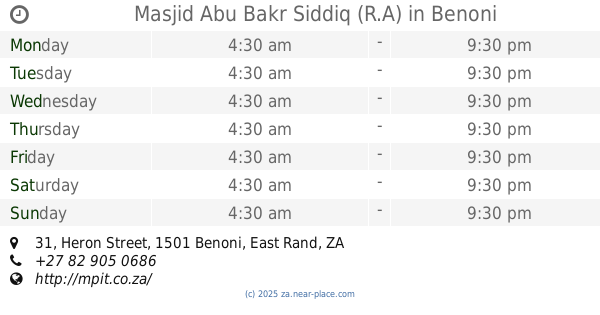
Masjid Abu Bakr Siddiq (R.A)
31 Heron Street, Mackenzie Park, Benoni
Mosque
Place of worship
Point of interest
Establishment
read more
10.788 km
Masjidus Safeena
139 Elephant Street, Villa Liza, Boksburg
Mosque
Place of worship
Point of interest
Establishment
read more
10.795 km
O.R. Tambo Basement Muslim Prayer Facility
13067 Short Term Parking Road, O.R. Tambo, Kempton Park
Mosque
Place of worship
Point of interest
Establishment
read more
10.963 km
Bedfordview Musallah / Masjid
4 Arterial Road West, Oriel, Germiston
Mosque
Place of worship
Point of interest
Establishment
read more
12.471 km
Edenvale Methodist Church
57 6th Avenue, Edenvale
Church
Place of worship
Point of interest
Establishment
read more
12.612 km
Die Gereformeerde Kerk Benoni
24 Miles Sharp Street, Rynfield, Benoni
Church
Place of worship
Point of interest
Establishment
read more
16.004 km
Revival City Alberton
120a Mc Bride Street, Alberton
Church
Place of worship
Point of interest
Establishment
read more
19.761 km
Dutch Reformed Church Of Africa church Zesfontein
Zesfontein, 287 Botha Street, Shangrila, Benoni
Church
Place of worship
Point of interest
Establishment
read more
📑
all categories
Accounting
Administrative area level 1
Administrative area level 2
Airport
Amusement park
Aquarium
Art gallery
Atm
Bakery
Bank
Bar
Beauty salon
Bicycle store
Book store
Bowling alley
Bus station
Cafe
Campground
Car dealer
Car rental
Car repair
Car wash
Casino
Cemetery
Church
City hall
Clothing store
Colloquial area
Convenience store
Courthouse
Dentist
Department store
Doctor
Electrician
Electronics store
Embassy
Establishment
Finance
Fire station
Florist
Food
Funeral home
Furniture store
Gas station
General contractor
Grocery or supermarket
Gym
Hair care
Hardware store
Health
Hindu Temple
Home goods store
Hospital
Insurance agency
Jewelry store
Laundry
Lawyer
Library
Light rail station
Liquor store
Local government office
Locality
Locksmith
Lodging
Meal delivery
Meal takeaway
Mosque
Movie rental
Movie theater
Moving company
Museum
Natural feature
Neighborhood
Night club
Painter
Park
Parking
Pet store
Pharmacy
Physiotherapist
Place of worship
Plumber
Point of interest
Police
Political
Post office
Premise
Real estate agency
Restaurant
Roofing contractor
Route
Rv park, camping
School
Shoe store
Shopping mall
Spa
Stadium
Storage
Store
Subpremise
Subway station
Supermarket
Synagogue
Taxi stand
Train station
Transit station
Travel agency
University
Veterinary care
Zoo
administrative area level 3
sublocality level 1
sublocality level 2
↑