Point of interest nearby Winnie Mandela Park Zone 7 Ground
South Africa
Point of interest nearby Winnie Mandela Park Zone 7 Ground
Winnie Mandela Park Zone 7 Ground
Tembisa, 1632, South Africa
contacts phone
:
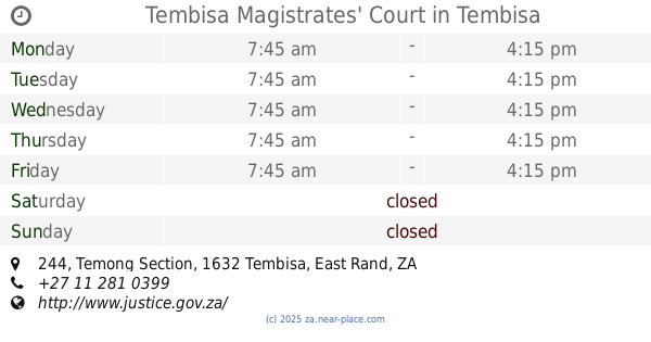
+27
Latitude:
-25.9803135
, Longitude:
28.2190215
larger map & directions
read more
nearest Point of interest
566 m
Winnie Mandela Library
Margaret Zyma, Winnie Mandela, Johannesburg
Library
Point of interest
Establishment
read more
1.217 km
Multiserv
34, Phumlani Mall, Olifantsfontein Road, Tembisa, Johannesburg
Locksmith
Laundry
Point of interest
Establishment
read more
1.593 km
Ntsika Mother and Child Health And Wellness (Sihewula Z)
Limpopo Street, 14991 G Malatsi Street, Ivory Park, Midrand
Hospital
Health
Point of interest
Establishment
read more
1.823 km
Maxco Truss Systems
5 Spanner Road, Clayville Industrial, Olifantsfontein
Roofing contractor
Home goods store
General contractor
Point of interest
Store
Establishment
read more
1.888 km
DRAFT KINGS FILMS
13408 Makhura Street, Ivory Park, Midrand
Movie theater
Point of interest
Establishment
read more
2.034 km
Olifantsfontein Fire Station
Industry Road, Clayville Industrial, Olifantsfontein
Fire station
Point of interest
Establishment
read more
2.095 km
Ivory Park Fire Station
8712 Freedom Drive, Midrand
Fire station
Point of interest
Establishment
read more
2.369 km
Makhulong Stadium
Star Street, Makulong, Tembisa
Stadium
Point of interest
Establishment
read more
2.41 km
DeGood Casino
2 Buthelezi Street, Ivory Park, Midrand
Casino
Point of interest
Establishment
read more
2.535 km
The Joint - Pub and Carwash
Tembisa, andrew mapheto and rev namane junction, makulong, Tembisa, Gauteng
Car wash
Bar
Restaurant
Food
Point of interest
Establishment
read more
3.04 km
Tembisa Police Station
244 Andrew Mapheto Drive, Tembisa, Johannesburg
Police
Point of interest
Establishment
read more
3.093 km
Tembisa Magistrates' Court
244 Temong Section, Tembisa
Courthouse
Point of interest
Establishment
read more
3.189 km
Civic Centre - Tembisa Municipal Offices
445 Shipvalley Street, Igqagqa, Tembisa
City hall
Local government office
Point of interest
Establishment
read more
3.264 km
Regional Science Centre, Tirupati
Planetarium Road, Tirupati
Museum
Point of interest
Establishment
read more
3.322 km
Caprivi
750 Reverend R.T.J. Namane Drive, Tembisa, Johannesburg
Night club
Point of interest
Establishment
read more
3.349 km
Tembisa Library
Ngomane Street, Tembisa, Johannesburg
Library
Point of interest
Establishment
read more
3.975 km
Tembisa Fire Station
Andrew Mapheto Drive, Emkantini, Tembisa
Fire station
Point of interest
Establishment
read more
4.079 km
Impophoma Primary
4024 Molele Street, Ivory Park, Midrand
School
Point of interest
Establishment
read more
4.283 km
Ivory Park Sport Stadium
Ivory Park 2, Freedom Drive, Midrand, Johannesburg
Stadium
Point of interest
Establishment
read more
4.513 km
Mairie d'Akom2
17 Cameroun Street, AKOM 2
City hall
Local government office
Point of interest
Establishment
read more
4.734 km
Dr LT Mphahlele
1632, 1 Yellowbird Street, Lekaneng, Tembisa
Hospital
Health
Point of interest
Establishment
read more
4.978 km
newcastle airport
702 16june road ivory park ext02, Midrand
Airport
Point of interest
Establishment
read more
5.5 km
Esiqongweni Ground
Brian Street, Esiqongweni, Tembisa
Stadium
Point of interest
Establishment
read more
6.459 km
Rabie Ridge Community Hall
Rabie Ridge Clinic, Korhaan Crescent, Rabie Ridge, Johannesburg
City hall
Local government office
Point of interest
Establishment
read more
6.593 km
Rabie Ridge Police Station
1312 Stilt Avenue, Rabie Ridge, Johannesburg
Police
Point of interest
Establishment
read more
📑
all categories
Accounting
Administrative area level 1
Administrative area level 2
Airport
Amusement park
Aquarium
Art gallery
Atm
Bakery
Bank
Bar
Beauty salon
Bicycle store
Book store
Bowling alley
Bus station
Cafe
Campground
Car dealer
Car rental
Car repair
Car wash
Casino
Cemetery
Church
City hall
Clothing store
Colloquial area
Convenience store
Courthouse
Dentist
Department store
Doctor
Electrician
Electronics store
Embassy
Establishment
Finance
Fire station
Florist
Food
Funeral home
Furniture store
Gas station
General contractor
Grocery or supermarket
Gym
Hair care
Hardware store
Health
Hindu Temple
Home goods store
Hospital
Insurance agency
Jewelry store
Laundry
Lawyer
Library
Light rail station
Liquor store
Local government office
Locality
Locksmith
Lodging
Meal delivery
Meal takeaway
Mosque
Movie rental
Movie theater
Moving company
Museum
Natural feature
Neighborhood
Night club
Painter
Park
Parking
Pet store
Pharmacy
Physiotherapist
Place of worship
Plumber
Point of interest
Police
Political
Post office
Premise
Real estate agency
Restaurant
Roofing contractor
Route
Rv park, camping
School
Shoe store
Shopping mall
Spa
Stadium
Storage
Store
Subpremise
Subway station
Supermarket
Synagogue
Taxi stand
Train station
Transit station
Travel agency
University
Veterinary care
Zoo
administrative area level 3
sublocality level 1
sublocality level 2
↑